
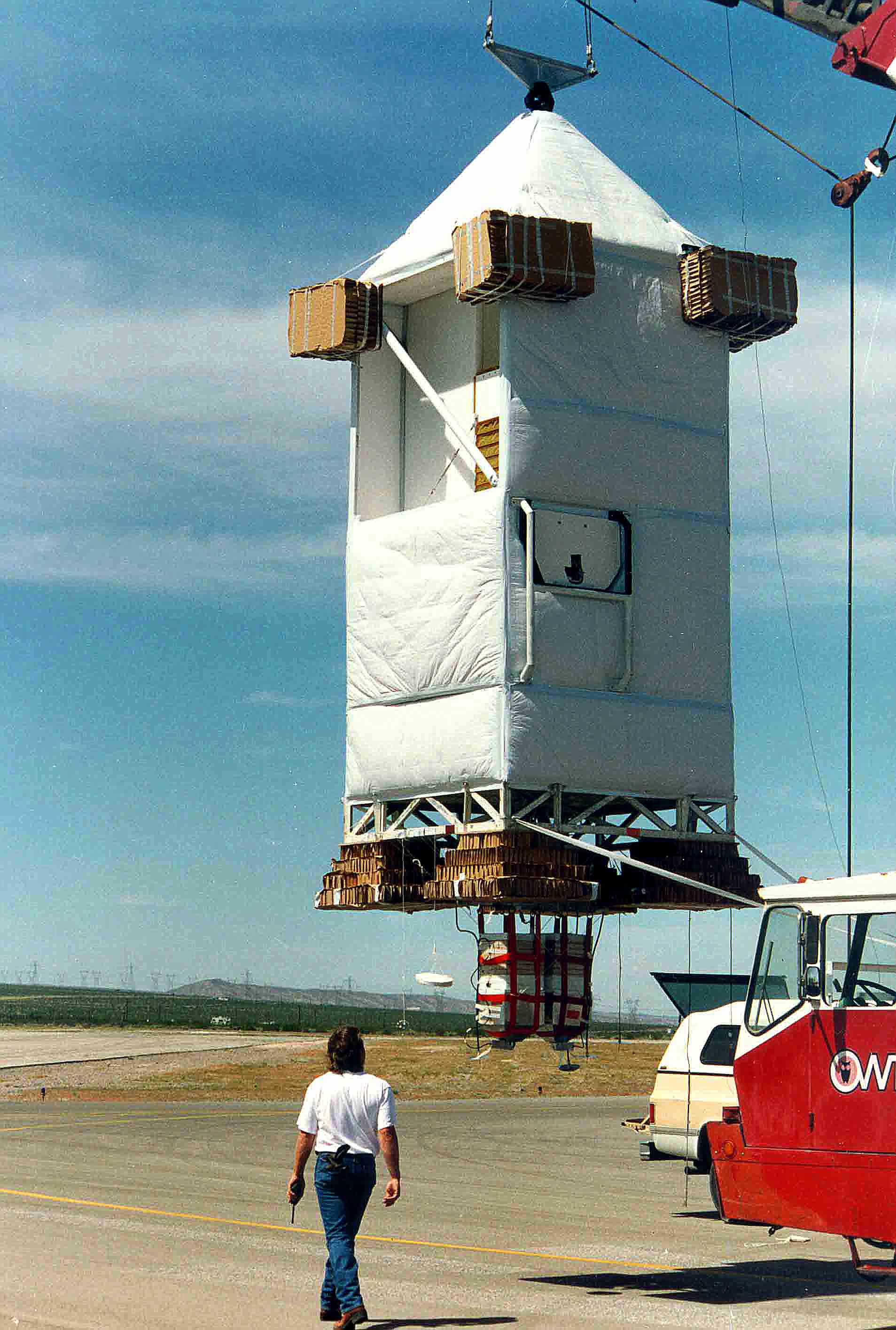
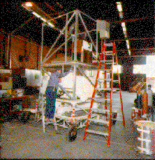
LEFT: The JPL gondola suspended from the launch vehicle during pre-launch check-out. The MkIV instrument is one of four JPL instruments flown together on this gondola. The others are SLS, Ozone and FILOS. Crush pads (brown) are fixed beneath the four bottom corners and around the upper corners of the gondola to minimize the shock of landing. Below the gondola hangs the ballast hoppers, containing 1200 lbs of steel shot. The total payload weight for this flight was over 4000 lbs.
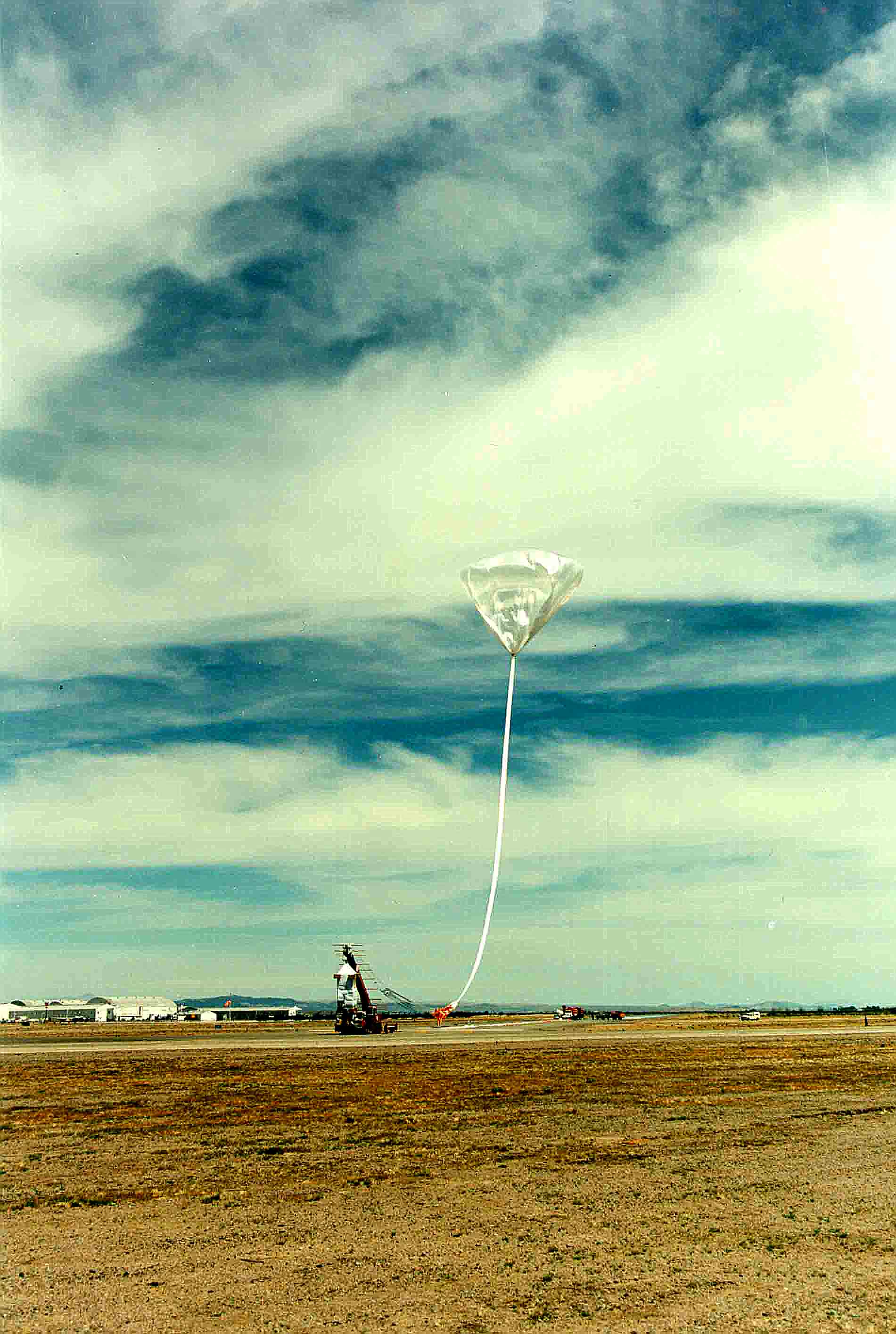
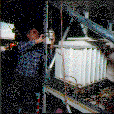
MIDDLE: Release of the balloon. The launch vehicle shown close-up in the previous photograph is visible in the lower center of this photograph. It must be maneuvered directly beneath the balloon to prevent the gondola swinging into the ground after release.
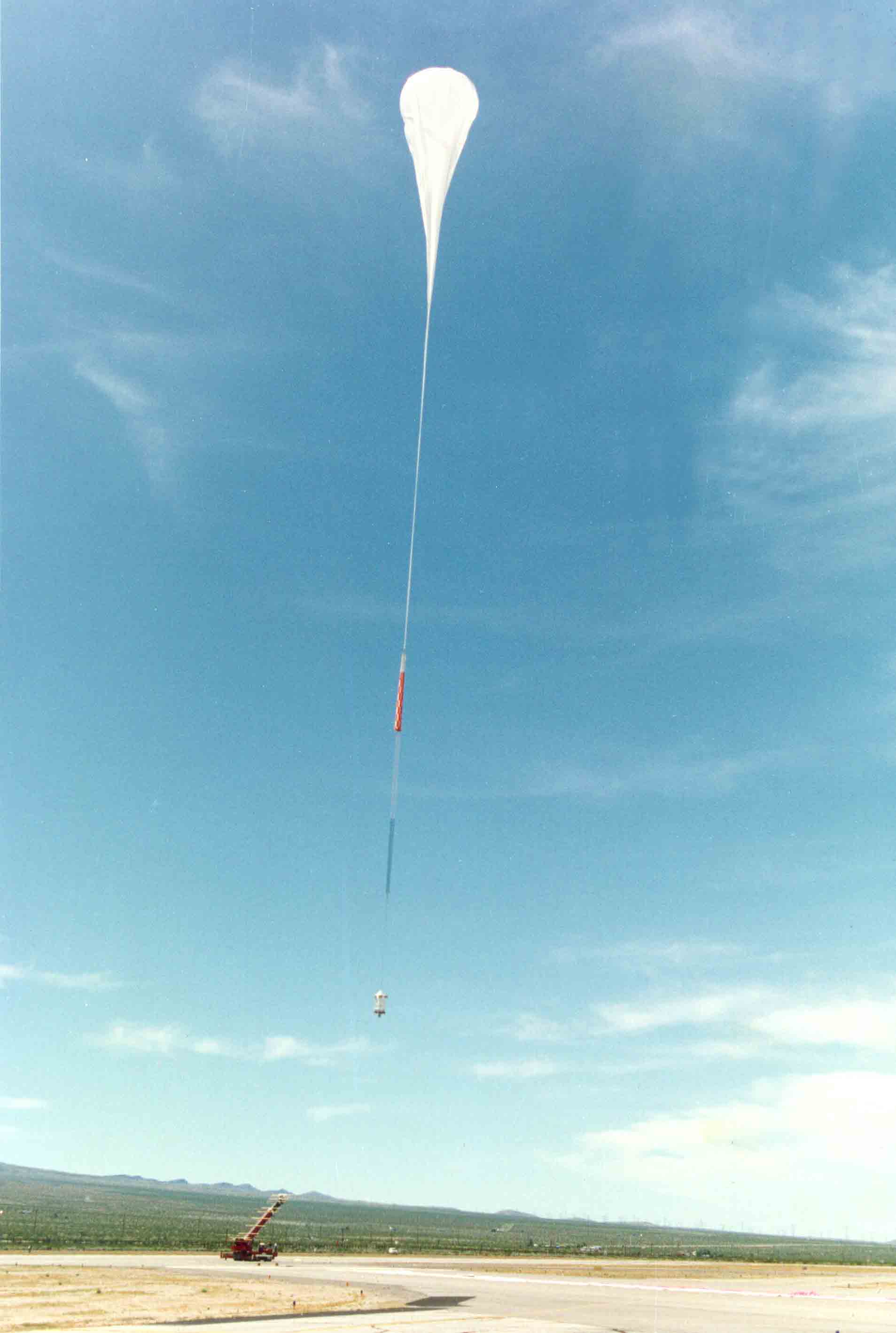
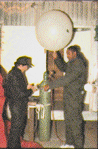
RIGHT: Seconds later, the gondola payload is released from the launch vehicle and begins its 160 minute ascent to 37 km (23 miles or 121,400 feet) altitude. At launch, only a small fraction (1/300) of the total balloon volume is filled with helium. As the balloon ascends the helium expands, so that by 37 km altitude the entire 29 million cubic foot balloon is fully inflated. After 10 hours at float altitude this flight was terminated and the gondola safely descended back down by parachute (the orange object connecting the balloon to the launch vehicle) landing in New Mexico.
| Date | Flight # | Tangent Latitude (N) (at 20km) | Tangent Longitude (E) (at 20km) | Minimum Altitude (km) | Balloon Altitude (km) | Balloon Volume (MCF) | Launch Site | Event |
|---|---|---|---|---|---|---|---|---|
| 05-Oct-1989 | 1 | 34.6 | -105.3 | 13 | 37 | 29 | Ft. Sumner, New Mexico | Sunset |
| 27-Sep-1990 | 2 | 34.2 | -105.6 | 10 | 36 | 29 | Ft. Sumner, New Mexico | Sunset |
| 05-May-1991 | 3 | 37.5 | -111.5 | 15 | 37 | 29 | Ft. Sumner, New Mexico | Sunset |
| 06-May-1991 | 36.5 | -113.0 | 15 | 32 | 29 | Ft. Sumner, New Mexico | Sunrise | |
| 14-Sep-1992 | 4 | 35.2 | -110.9 | 23 | 39 | 29 | Ft. Sumner, New Mexico | Sunset |
| 15-Sep-1992 | 35.3 | -104.0 | 22 | 41 | 29 | Ft. Sumner, New Mexico | Sunrise | |
| 03-Apr-1993 | 5 | 34.8 | -114.8 | 17 | 37 | 29 | Daggett, California | Sunset |
| 25-Sep-1993 | 6 | 34.0 | -107.5 | 6 | 38 | 29 | Ft. Sumner, New Mexico | Sunset |
| 26-Sep-1993 | 33.1 | -95.3 | 13 | 38 | 29 | Ft. Sumner, New Mexico | Sunrise | |
| 22-May-1994 | 7 | 36.1 | -108.6 | 14 | 36 | 29 | Ft. Sumner, New Mexico | Sunset |
| 23-May-1994 | 36.3 | -100.9 | 11 | 37 | 29 | Ft. Sumner, New Mexico | Sunrise | |
| 24-Jul-1996 | 8 | 56.7 | -100.9 | 11 | 24* | 28 | Lynn Lake, Manitoba | Ascent* |
| 28-Sep-1996 | 9 | 32.7 | -113.1 | 4 | 38 | 29 | Ft. Sumner, New Mexico | Sunset |
| 08-May-1997 | 10 | 68.7 | -146.0 | 8 | 38 | 24 | Fairbanks, Alaska | Sunrise |
| 08-Jul-1997 | 11 | 66.4 | -148.3 | 7 | 32 | 11 | Fairbanks, Alaska | Ascent |
| 08-Jul-1997 | 11 | 64.7 | -150.2 | 9 | 32 | 11 | Fairbanks, Alaska | Descent |
| 03-Dec-1999 | 12 | 64.2 | +19.3 | 6 | 34 | 11 | Esrange, Sweden | Sunset |
| 15-Mar-2000 | 13 | 67.8 | +34.2 | 11 | 29 | 4 | Esrange, Sweden | Sunrise |
| 16-Dec-2002 | 14 | 64.4 | +31.2 | 12 | 31 | 5 | Esrange, Sweden | Sunrise |
| 01-Apr-2003 | 15 | 68.3 | +35.2 | 11 | 32 | 5 | Esrange, Sweden | Sunrise |
| 19-Sep-2003 | 16 | 34.3 | -113.3 | 7 | 36 | 28 | Ft. Sumner, New Mexico | Sunset |
| 23-Sep-2004 | 17 | 33.8 | -109.2 | 11 | 38 | 28 | Ft. Sumner, New Mexico | Sunset |
| 20-Sep-2005 | 18 | 35.2 | -114.1 | 11 | 39 | 39 | Ft. Sumner, New Mexico | Sunset |
| 21-Sep-2005 | 34.0 | -110.3 | 13 | 29 | 39 | Ft. Sumner, New Mexico | Sunrise | |
| 7-Feb-2007 | 19 | 67.9 | +21.0 | - | 34 | 12 | Esrange, Sweden | Ascent# |
| 22-Feb-2007 | 20 | 67.9 | +21.1 | 25 | 34 | 12 | Esrange, Sweden | Ascent# |
| 22-Sep-2007 | 21 | 35.2 | -114.1 | 10 | 38 | 29 | Ft. Sumner, New Mexico | Sunset |
| 23-Sep-2007 | 34.0 | -110.3 | 13 | 38 | 29 | Ft. Sumner, New Mexico | Sunrise | |
| 23-Sep-2011 | 22 | 34.5 | -108.8 | 6 | 39 | 29 | Ft. Sumner, New Mexico | Sunset |
| 24-Sep-2011 | 35.7 | -96.3 | 14 | 40 | 29 | Ft. Sumner, New Mexico | Sunrise | |
| 13-Sep-2014 | 23 | 36.2 | -112.5 | 7 | 39 | 29 | Ft. Sumner, New Mexico | Sunset |
| 14-Sep-2014 | 35.6 | -103.5 | 8 | 40 | 29 | Ft. Sumner, New Mexico | Sunrise | |
| 27-Sep-2016 | 24 | 36.0 | -110.5 | 11 | 39 | 29 | Ft. Sumner, New Mexico | Sunset |
| 07-Oct-2019 | 25 | 33.4 | -109.7 | 7 | 38 | 29 | Ft. Sumner, New Mexico | Sunset |
| 25-Sep-2021 | 26 | 33.5 | -107.5 | 8 | 39 | 29 | Ft. Sumner, New Mexico | Sunset |
| 26-Sep-2021 | 33.0 | -97.8 | 10 | 40 | 29 | Ft. Sumner, New Mexico | Sunrise | |
| 27-Sep-2023 | 27 | 34.5 | -108.7 | 11 | 39 | 29 | Ft. Sumner, New Mexico | Sunset |
 Go back to the
previous page
Go back to the
previous page